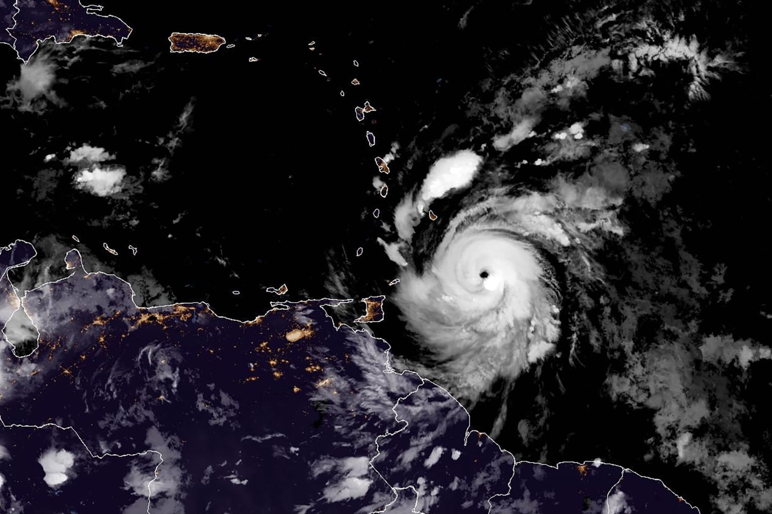
Hurricane Beryl entered the southeastern Caribbean on Monday, bringing “life-threatening winds and dangerous storm surges” to the southern Windward Islands, which include Grenada, St. Vincent and the Grenadines and Martinique.
The extremely dangerous Category 4 storm hit Carriacou Island in Grenada on Monday with winds of 150 mph.
Residents of Grenada, the Grenadines and Carriacou Island were warned Monday afternoon to leave their shelters as winds will rapidly increase within Beryl’s eyewall. “Stay where you are during these life-threatening conditions and do not venture out into the eye of the storm,” the National Hurricane Center warned.
Up to 10 inches of rain is possible. Grenadines The storm surge reached 6 inches across Barbados. Hurricane warnings were in effect for Barbados, St. Vincent and the Grenadines, Grenada and Tobago. A hurricane warning was also issued for Jamaica.
According to the National Hurricane Center, storm surges of 6 to 9 feet could occur near where the center of Hurricane Beryl makes landfall in the hurricane warning area. Large, destructive waves are possible near the coast.
Grenada Prime Minister Deacon Mitchell said there were already reports of “extensive storm surge”, damage to buildings and power outages across the country.
“There is potential for more damage,” Mitchell said, adding that there were no reports of casualties or injuries.
Beryl is the first Category 4 hurricane on record in June. It is also the oldest Category 4 hurricane on record in the Atlantic hurricane season, surpassing the previous record set by Hurricane Dennis on July 8, 2005.
Videos shared by UNICEF in the Eastern Caribbean show: Severe storm hits southern coast of Barbados And Strong winds in Saint LuciaThe US Embassy in Barbados reported: Power outages and floods in some areas.
The center said that Hurricane Beryl is currently located about 35 miles northeast of Grenada. Maximum sustained winds are now 140 mph. mph and moving west at 20 mph.
Beryl had been gaining strength for the past week, strengthening from a tropical depression to a Category 3 hurricane in 42 hours. It then became a Category 4 hurricane within 48 hours. According to ClimateCentral.orgHurricanes are getting stronger at a faster rate due to warmer waters caused by climate change.
The agency added that Storm Beryl will continue to move westward, across the southeastern and central Caribbean Sea until at least Wednesday.
“Potentially catastrophic wind damage is expected in areas where the Beryl core is moving,” the company added.
The hurricane’s winds extended 35 miles from the center, while tropical storm-force winds could extend 115 miles. He added that Grantley Adams International Airport in Barbados recorded wind gusts of up to 45 miles per hour.
Beryl became an “extremely dangerous” Category 4 storm as it approached the islands early Sunday before stabilizing slightly. While winds decreased slightly overnight, the center said “the area of strong winds has grown, so the hurricane risk is likely to affect a larger area.”
In Barbados, officials began opening emergency shelters on Sunday evening and ordered all businesses to close by 7 p.m. The water authority also urged people to stock up on drinking water as water lines would be shut off as a precaution.
Thousands of people descended on the Caribbean island to watch the World Cup cricket final over the weekend. But bad weather prevented many, including the victorious Indian team, from leaving.
“Some of them have never been through a storm before,” Premier Mia Mottley said, according to the Associated Press.
Early Monday, the country’s weather bureau said it had recorded wind gusts of up to 64 mph. Marine conditions “continue to deteriorate,” it said in an advisory, adding that Beryl’s center was expected to move about 80 miles south of the island.
While Beryl is expected to move further west, “it is too early to discuss what could happen with Beryl if it reaches the Gulf of Mexico,” US meteorologists added.
The hurricane is likely to remain in the Caribbean Sea for the rest of the week before hitting the Yucatan Peninsula as a Category 2 storm. The hurricane is expected to weaken to a tropical storm as it moves toward the southwestern Gulf of Mexico.

“Travel specialist. Typical social media scholar. Friend of animals everywhere. Freelance zombie ninja. Twitter buff.”


More Stories
Taiwan is preparing to face strong Typhoon Kung-ri
Israel orders residents of Baalbek, eastern Lebanon, to evacuate
Zelensky: North Korean forces are pushing the war with Russia “beyond the borders”