Tropical Storm Lee is expected to become an “extremely dangerous” hurricane by the weekend
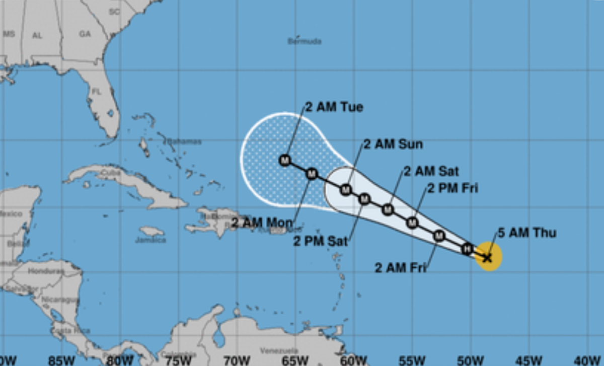
Hurricane Lee rapidly strengthened to a Category 5 storm Thursday night as it moved toward the Caribbean islands, with “life-threatening” conditions expected in the coming days.
The National Hurricane Center said in its 11 p.m. warning that the storm could see “more strength” overnight, which could make it one of the rarest hurricanes in the Atlantic.
Hurricane Lee was located about 705 miles (1,135 km) east of the northern Leeward Islands and had maximum sustained winds of 160 mph (260 kph).
Forecasters say Lee could develop into a “brutal 180 mph” storm by Friday morning.
The forecaster said the storm is expected to pass north of the northern Leeward Islands, the Virgin Islands and Puerto Rico over the weekend and into early next week.
The NHC warned that dangerous beach conditions are expected to develop around the western Atlantic Ocean through early next week.
Lee is the twelfth storm of the Atlantic hurricane season, which runs from June 1 to November 30.
Hurricane Lee could intensify further into a “monster” storm.
Experts said Lee’s rapid strength into a Category 5 hurricane on Thursday made it one of the “fastest intense Atlantic hurricanes on record,” while the National Hurricane Center warned the storm could intensify further by Friday morning.
“Hurricane Lee has explosively intensified into a Category 5 storm and is expected to peak as a 180mph Category 5 monster,” Colin McCarthy, who tracks tropical storms, wrote on X, formerly known as Twitter.
Experts have warned that if Hurricane Lee strengthens and reaches speeds of 180 mph, it will be the ninth storm in the Atlantic to reach that level.
“If that happened, it would put Lee in the elite club, with 8 other storms gusting up to 180 mph. There were 5 Atlantic hurricanes on record with stronger winds,” wrote meteorologist Jeff Berardelli.
Stuti MishraSeptember 8, 2023 06:02
Hurricane Lee is rapidly intensifying into an “extremely dangerous” Category 5 storm
Hurricane Lee rapidly strengthened to a Category 5 storm Thursday night as it moved toward the Caribbean islands, with “life-threatening” conditions expected in the coming days.
The National Hurricane Center said in its 11 p.m. warning that the storm could see “more strength” overnight, which could make it one of the rarest hurricanes in the Atlantic.
Hurricane Lee was located about 705 miles (1,135 km) east of the northern Leeward Islands and had maximum sustained winds of 160 mph (260 kph).
Stuti MishraSeptember 8, 2023 05:02
What is the El Niño phenomenon and why do hurricanes intensify this year?
After three years of cooler La Niña events, which often lead to slightly lower global temperatures, the World Meteorological Organization announced on Tuesday that El Niño conditions exist and are expected to gradually intensify in the winter.
The last significant El Niño event occurred in 2016, which became the warmest year the world has seen since records began.
A repeat in 2023, when the pace of global warming accelerated by man-made carbon emissions, threatens a “double whammy”, according to the Meteorological Organization, which has warned that there is a 90 per cent chance of it continuing through the end of the year.
This means that the potential for potentially life-threatening extreme weather events has also increased, prompting WMO officials to warn governments around the world to prepare.
Greg GraziosiSeptember 8, 2023 at 04:00
‘super normal’
National Oceanic and Atmospheric Administration Be warned in August This year’s season will produce a higher than usual number of storms. Between 14 and 21 named storms are expected. The agency said that between six and 11 of these areas may turn into hurricanes, and two to five of them are likely to turn into major hurricanes.
Meanwhile, AccuWeather updated its forecast, forecasting three to five Category 3 hurricanes or stronger this season, compared to one to three in its previous analysis.
Greg GraziosiSeptember 8, 2023 at 03:00
Watch: Hurricane Lee will continue to intensify in the coming days
Hurricane Lee will continue to intensify in the coming days
Greg GraziosiSeptember 8, 2023 at 02:00
Pictured: Hurricane Lee from space
Hurricane Lee was captured by NOAA satellite Thursday as it rotated toward the Leeward Islands.
Hurricane Lee is seen by satellite as it rotates toward the Lesser Antilles in the Caribbean
(NOAA)
Greg GraziosiSeptember 8, 2023 at 01:00
Watch: Typhoon Lee is expected to be ‘very dangerous’
Typhoon Lee expected to be ‘extremely dangerous’
Greg GraziosiSeptember 8, 2023 00:00
Hurricanes are getting stronger. this is the reason
As the global average temperature rises, largely due to carbon emissions from burning fossil fuels, the oceans are taking a hit.
The oceans have absorbed 90% of the warming in recent decades, and all that extra heat is driving water temperatures to historic levels.
Warmer waters increase tropical cyclones with more heavy rain and storm surges as they come ashore. While the frequency of tropical storm cyclones is not increasing, the probability of them becoming stronger and more destructive has increased by about 8 percent per decade globally. the past 40 years, according to climatologists.
The proportion of category 4 and 5 tropical cyclones worldwide is expected to increase in the coming decades due to human-caused global warming, according to the latest report from the United Nations’ Intergovernmental Panel on Climate Change.
The Atlantic hurricane season, which runs from June 1 to November 30, is expected to be above average this year.
Louise BoyleSeptember 7, 2023 at 23:20
“much higher than usual”
The National Oceanic and Atmospheric Administration said last month that record high ocean temperatures and a delayed El Niño double the chances of a bad Atlantic hurricane season this summer and fall.
With the Atlantic hurricane season much higher than normal so far, the National Oceanic and Atmospheric Administration (NOAA) has increased the number of storms expected and how busy the season will be.
Previous expectations were more inclined towards a season close to normal by 40%, but the chance of a normal season has now decreased to 25%.
Greg GraziosiSeptember 7, 2023 at 23:00
Spaghetti models show the possible tracks of Hurricane Lee
The latest spaghetti models of Hurricane Lee show it making a northward turn – and in some cases, a turn that brings it close to the eastern coasts of the United States and Canada – as it moves across the Atlantic Ocean.
Hurricane Lee became a Category 4 storm Thursday afternoon and is expected to become a Category 5 storm before it begins to slow.
A spaghetti model showing the potential tracks of Hurricane Lee
(National Center for Atmospheric Research)
Greg GraziosiSeptember 7, 2023 at 22:44

“Travel specialist. Typical social media scholar. Friend of animals everywhere. Freelance zombie ninja. Twitter buff.”


More Stories
Taiwan is preparing to face strong Typhoon Kung-ri
Israel orders residents of Baalbek, eastern Lebanon, to evacuate
Zelensky: North Korean forces are pushing the war with Russia “beyond the borders”